









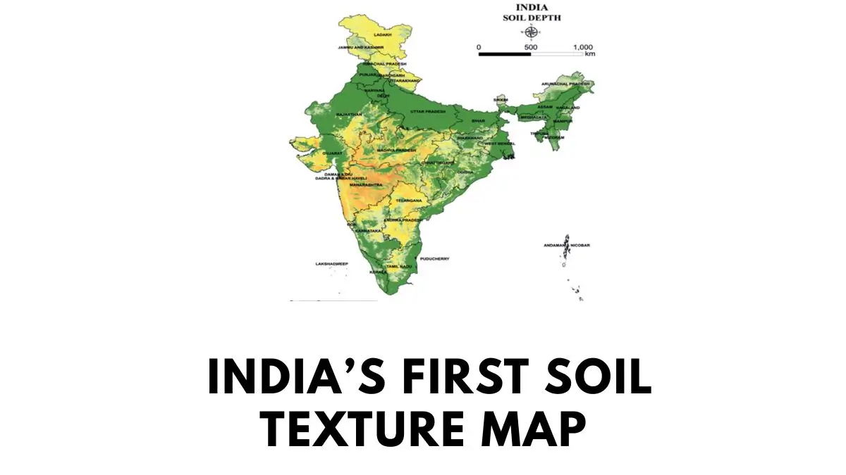
NBSS&LUP digital soil texture map is India’s first digital soil texture map, developed under ICAR to support precision agriculture, crop planning and sustainable soil management.
A Major Milestone in India’s Soil Mapping
The National Bureau of Soil Survey and Land Use Planning (NBSS&LUP) has developed India’s first Digital Soil Texture Map, marking an important development in agricultural science, soil resource management and precision farming. The map provides digitised information on soil texture at a highly detailed level across the country. It was released on July 16, 2026, during the 98th Foundation Day celebrations of the Indian Council of Agricultural Research (ICAR).
Understanding the Importance of Soil Texture
Soil texture refers to the relative proportion of sand, silt and clay particles present in soil. It is an important physical property because it influences water retention, drainage, aeration, nutrient availability and root development. Different crops require different soil conditions, making soil texture information useful for agricultural planning.
The new digital map can help identify whether soil in a particular area is predominantly sandy, loamy, clayey or belongs to another texture class. This information can support farmers, agricultural scientists and policymakers in making better decisions related to crop selection and land management.
Role of NBSS&LUP in the Initiative
NBSS&LUP is a specialised institution working under the Indian Council of Agricultural Research. The organisation is headquartered in Nagpur, Maharashtra, and focuses on soil survey, soil resource assessment and land-use planning. Its development of the Digital Soil Texture Map represents an important application of scientific data and digital technology in agriculture.
Benefits for Farmers and Agriculture
The availability of detailed soil texture information can improve agricultural decision-making. Sandy soils generally allow faster water drainage but may retain less water, while clay-rich soils can retain more water and nutrients but may have drainage limitations. Loamy soils often provide a more balanced combination of drainage, aeration and moisture retention.
With better knowledge of soil texture, farmers can make informed decisions about irrigation, crop suitability and soil management practices. Such information may also support more efficient use of agricultural inputs and promote sustainable farming.
Significance for Digital and Precision Agriculture
The development of India’s first Digital Soil Texture Map is significant because agriculture is increasingly moving towards data-driven planning. Digital soil information can support precision agriculture, in which farming decisions are based on the specific characteristics of land rather than broad assumptions.
The map can also assist government agencies and researchers in preparing location-specific agricultural strategies. Better soil data can contribute to sustainable land use, improved productivity and more efficient management of natural resources.
Relevance for Competitive Examinations
For government exam aspirants, this development is important for questions related to agriculture, geography, environmental science, ICAR and soil resources. Candidates should remember that the Digital Soil Texture Map was developed by NBSS&LUP, an organisation under ICAR. They should also understand the basic components of soil texture: sand, silt and clay.
The development reflects the growing importance of geospatial and digital technologies in Indian agriculture and can be linked with topics such as precision farming, sustainable agriculture, soil conservation and digital governance.

Why This News is Important
Strengthening Scientific Agriculture
The development of the Digital Soil Texture Map is important because soil is one of the most critical natural resources supporting agriculture. Accurate information about soil properties can help improve crop planning and farm management. Soil texture influences the movement and storage of water, nutrient retention and root growth. Therefore, detailed digital information can help make agricultural practices more scientific and location-specific.
Supporting Sustainable Land Management
India faces challenges related to land degradation, water scarcity and declining soil quality in several regions. Improved knowledge of soil characteristics can support more appropriate land-use decisions. The Digital Soil Texture Map can provide a scientific basis for managing agricultural land according to its physical properties and potential.
Promoting Data-Driven Agriculture
The initiative also represents India’s growing use of digital technologies in the agricultural sector. Reliable soil data can support precision farming, agricultural research and policy planning. It can help shift agricultural decision-making from general recommendations towards more area-specific approaches.
Important for Government Exam Preparation
The news is particularly important for UPSC, State PCS, agriculture examinations, SSC and other government examinations because it combines agriculture, geography, environmental science and scientific institutions. Students should remember the name of the institution involved, its parent organisation, its headquarters and the basic concept of soil texture.
Historical Context and Background
Evolution of Soil Survey in India
Scientific soil survey has long played an important role in agricultural planning and land resource management in India. Soil surveys help identify and classify different types of soil and assess their suitability for agriculture and other land uses. Such information is essential for crop planning, irrigation management and conservation.
Establishment and Role of NBSS&LUP
The National Bureau of Soil Survey and Land Use Planning was established to strengthen scientific understanding of India’s soil resources and support land-use planning. It functions under the Indian Council of Agricultural Research and is headquartered in Nagpur. The institution has contributed to soil resource mapping and the development of soil information systems.
Growing Importance of Digital Soil Information
Modern agriculture increasingly depends on digital databases, geospatial technologies and location-specific information. Digital soil mapping allows scientific information to be organised and analysed more efficiently. India’s first Digital Soil Texture Map represents another step in integrating soil science with digital technology for improved agricultural planning.
Key Takeaways from Digital Soil Texture Map of India
| S. No. | Key Takeaway |
|---|---|
| 1 | NBSS&LUP developed India’s first Digital Soil Texture Map. |
| 2 | NBSS&LUP functions under the Indian Council of Agricultural Research (ICAR). |
| 3 | The headquarters of NBSS&LUP is located in Nagpur, Maharashtra. |
| 4 | Soil texture is mainly determined by the proportion of sand, silt and clay particles. |
| 5 | The map can support precision agriculture, crop planning, sustainable land management and scientific decision-making. |
FAQs: Frequently Asked Questions
1. What is the major development discussed in this news?
The National Bureau of Soil Survey and Land Use Planning (NBSS&LUP) has developed India’s first Digital Soil Texture Map. It provides detailed digital information about soil texture across India.
2. Which organisation developed India’s first Digital Soil Texture Map?
The map was developed by the National Bureau of Soil Survey and Land Use Planning (NBSS&LUP).
3. Under which organisation does NBSS&LUP function?
NBSS&LUP functions under the Indian Council of Agricultural Research (ICAR).
4. Where is the headquarters of NBSS&LUP located?
The headquarters of NBSS&LUP is located in Nagpur, Maharashtra.
5. What is soil texture?
Soil texture refers to the relative proportion of sand, silt and clay particles present in soil. It is an important physical characteristic that influences water retention, drainage and crop growth.
6. What are the major components used to determine soil texture?
The three primary soil separates used to determine soil texture are sand, silt and clay.
7. Why is a Digital Soil Texture Map important for agriculture?
It can provide location-specific information about soil properties, helping with crop selection, irrigation planning, soil management and precision agriculture.
8. How can the map support precision agriculture?
Precision agriculture uses location-specific information to optimise farming decisions. Digital soil texture information can help farmers and agricultural experts tailor irrigation, crop selection and soil-management practices to local conditions.
9. What is the significance of soil texture in water management?
Sandy soils generally allow faster drainage, whereas clay-rich soils tend to retain more water. Understanding soil texture can therefore help in developing more appropriate irrigation and water-management strategies.
10. Why is this development important for competitive examinations?
The topic connects agriculture, soil science, geography, environmental management, digital technology and ICAR-related institutions. Questions can be asked about NBSS&LUP, ICAR, soil texture and the purpose of the digital map.
Some Important Current Affairs Links