State with the Shortest Boundary with Uttar Pradesh
Geographical Overview of Uttar Pradesh
Uttar Pradesh (UP) is the fourth largest state in India, covering 240,928 square kilometers, making up 7.33% of India’s total area. As of the 2011 census, UP had a population of approximately 199.8 million, which has grown to an estimated 240 million. The state’s vast area and population highlight its significance within India.
Administrative Divisions of Uttar Pradesh
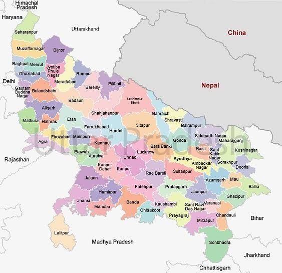
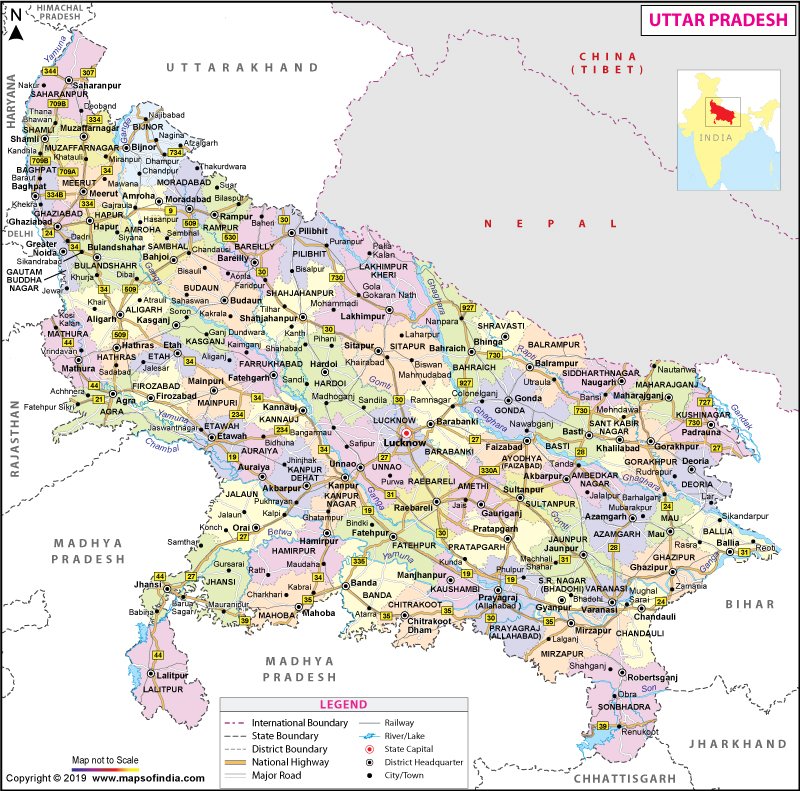
UP is divided into 75 districts, grouped into 18 divisions. The largest district by area is Lakhimpur Kheri, spanning 7,680 square kilometers, while Hapur is the smallest, covering only 660 square kilometers. The administrative complexity of the state is further marked by its 822 community development blocks, 17 municipal corporations, and 437 town panchayats.
States Sharing Borders with Uttar Pradesh
Uttar Pradesh shares its borders with nine states and one Union Territory, along with an international border with Nepal. These states are Himachal Pradesh, Uttarakhand, Haryana, Delhi (Union Territory), Rajasthan, Madhya Pradesh, Chhattisgarh, Jharkhand, and Bihar.
State with the Shortest Border with Uttar Pradesh
Himachal Pradesh shares the shortest boundary with Uttar Pradesh among all neighboring states. This minimal border interaction makes Himachal Pradesh the state with the least geographical connection to UP.
Cultural and Economic Significance
Uttar Pradesh is a cultural hub, known for its diverse traditions in music, dance, and arts. Economically, it is vital for India, being a major producer of sugarcane, wheat, and other crops. Additionally, UP is home to numerous historical and religious sites, attracting millions of tourists and pilgrims annually.

Why This News is Important
Significance for Competitive Exams
Understanding the geographical boundaries of Uttar Pradesh is crucial for students preparing for competitive exams. Knowledge of which state shares the shortest border with UP is a typical question in general knowledge sections of exams like UPSC, SSC, and state PSCs.
Geopolitical Understanding
Knowing the states that share borders with UP aids in comprehending India’s geopolitical landscape. It helps in understanding regional dynamics, which is essential for civil service aspirants aiming to grasp the complexities of Indian governance and administration.
Cultural and Economic Insights
The information about UP’s cultural and economic significance is valuable for exams focusing on Indian economy and culture. It highlights the state’s contribution to India’s GDP and its role as a cultural melting pot, which can be a part of descriptive answers in various competitive exams.
Administrative Knowledge
Details about the administrative divisions of UP provide insights into the state’s governance structure. This knowledge is beneficial for students preparing for exams with questions on Indian polity and administration.
Historical Context
Formation and Development of Uttar Pradesh
Uttar Pradesh, initially known as the United Provinces, was formed in 1937 and renamed in 1950. The state’s administrative evolution and its significance in India’s independence movement form a critical part of its history. The knowledge of UP’s formation and its subsequent development is vital for understanding its current geopolitical status.
Geographical Changes and Impact
Over the years, UP’s geographical and administrative boundaries have seen changes, impacting its political and economic landscape. The partition of states like Uttarakhand from UP in 2000 is a significant event that reshaped the state’s administrative divisions.
Cultural Heritage
UP has a rich cultural heritage, being the land of significant historical events like the first war of Indian independence in 1857. This historical context is crucial for students to understand the state’s current socio-political fabric.
Key Takeaways from the News about UP’s Borders
| Serial Number | Key Takeaway |
|---|---|
| 1 | Uttar Pradesh is the fourth largest state in India by area. |
| 2 | UP shares its borders with nine states and one Union Territory. |
| 3 | Himachal Pradesh has the shortest shared border with UP. |
| 4 | UP is a major cultural and economic hub in India. |
| 5 | The state is administratively divided into 75 districts and 18 divisions. |
Important FAQs for Students from this News
1. Which state shares the shortest boundary with Uttar Pradesh?
- Himachal Pradesh shares the shortest boundary with Uttar Pradesh.
2. How many districts are there in Uttar Pradesh?
- Uttar Pradesh is divided into 75 districts.
3. What is the largest district in Uttar Pradesh by area?
- Lakhimpur Kheri is the largest district by area in Uttar Pradesh.
4. Which international border does Uttar Pradesh share?
- Uttar Pradesh shares an international border with Nepal.
5. Why is understanding the geographical boundaries of Uttar Pradesh important for competitive exams?
- Knowledge of geographical boundaries is crucial for general knowledge sections in exams like UPSC, SSC, and state PSCs, helping students understand India’s geopolitical landscape.
Some Important Current Affairs Links


