Length of Indian Coastline: Key Insights and Implications
India boasts a diverse and extensive coastline that plays a significant role in its economic, environmental, and strategic landscape. Spanning several states and Union Territories, the Indian coastline is a hub of activity, supporting commerce, tourism, and biodiversity. This article delves into the details of the Indian coastline, its significance, and the recent updates regarding its length.
Coastline Overview
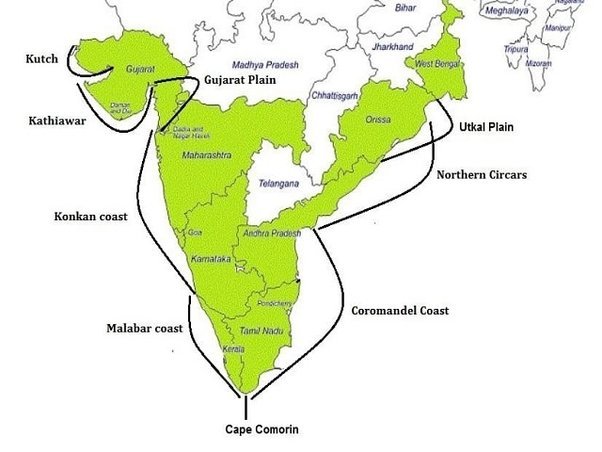
The Indian coastline stretches approximately 7,516.6 kilometers, encompassing the mainland and island territories. This expansive coastal stretch is divided among 9 coastal states, 4 Union Territories, and the island territories of Andaman and Nicobar Islands and Lakshadweep. Each of these regions contributes uniquely to the country’s maritime identity, offering a mix of bustling ports, serene beaches, and ecologically significant areas.
Economic Significance
The coastline is crucial for India’s economy, primarily through its ports which handle 90% of the country’s trade by volume and 70% by value. Major ports like Mumbai, Chennai, and Kolkata serve as gateways for international trade, while numerous minor ports support regional commerce. Additionally, the coastal regions are thriving centers for fishing, tourism, and offshore energy resources, contributing significantly to the national GDP.
Environmental Importance
India’s coastline is home to diverse ecosystems, including mangroves, coral reefs, and estuaries, which are vital for maintaining ecological balance. These ecosystems support a wide variety of flora and fauna, some of which are unique to these regions. Conservation efforts are critical in these areas to protect against environmental degradation and to preserve biodiversity.
Strategic and Security Aspects
Strategically, the Indian coastline is vital for national security. The Indian Navy and Coast Guard play crucial roles in patrolling and securing maritime borders against threats such as piracy, smuggling, and unauthorized fishing. The coastline also provides strategic depth and supports India’s stance in regional maritime affairs, especially in the Indian Ocean region.
Recent Developments
Recent assessments and technological advancements have led to more precise measurements of India’s coastline. The deployment of satellite imagery and geospatial technologies has refined our understanding of coastal dynamics, helping in better planning and management. These developments are crucial for addressing challenges like coastal erosion, rising sea levels, and the impact of climate change.

Why This News is Important
Significance for Exams
Understanding the length and details of the Indian coastline is crucial for students preparing for various government exams. Questions related to geography, environmental science, and national security often feature in exams like IAS, PSCS, and others. Hence, keeping abreast of such updates is vital.
Economic and Environmental Aspects
The economic and environmental importance of the Indian coastline cannot be overstated. Its role in trade, biodiversity, and tourism makes it a critical topic for exams focusing on economic geography and environmental studies. Recent updates provide fresh perspectives that can enhance students’ answers in competitive exams.
Strategic Insights
From a strategic viewpoint, the coastline’s role in national security and maritime affairs is significant. Understanding recent developments and their implications helps students prepare for questions related to national defense and international relations. This is particularly relevant for exams like CDS and other defense-related tests.
Historical Context
Previous Measurements
Historically, the length of India’s coastline was measured using traditional surveying methods. The transition to modern techniques, including satellite imagery and geospatial technologies, marks a significant shift in accuracy and reliability. These advancements reflect broader trends in geographic and environmental sciences, illustrating the evolution of technology in understanding and managing natural resources.
Coastal Management Policies
India has a history of implementing coastal management policies aimed at balancing development with conservation. The Coastal Regulation Zone (CRZ) notifications, first issued in 1991, are key regulatory frameworks governing coastal activities. These policies have evolved over the years, incorporating scientific inputs and addressing emerging challenges such as climate change and coastal erosion.
Key Takeaways from the Length of Indian Coastline
| Serial Number | Key Takeaway |
|---|---|
| 1 | India’s coastline measures approximately 7,516.6 kilometers. |
| 2 | It spans 9 coastal states, 4 Union Territories, and island territories. |
| 3 | Coastal ports handle 90% of India’s trade by volume and 70% by value. |
| 4 | The coastline is crucial for biodiversity, featuring mangroves, coral reefs, and estuaries. |
| 5 | Recent technological advancements have improved the precision of coastal measurements. |
Important FAQs for Students from this News
Q1: What is the total length of India’s coastline?
A1: India’s coastline measures approximately 7,516.6 kilometers, including the mainland and island territories.
Q2: How many states and Union Territories in India have a coastline?
A2: India has 9 coastal states and 4 Union Territories with coastlines.
Q3: Why is the Indian coastline economically significant?
A3: The Indian coastline is crucial for the economy because it handles 90% of India’s trade by volume and 70% by value through its major and minor ports. It also supports fishing, tourism, and offshore energy resources.
Q4: What ecosystems are found along the Indian coastline?
A4: The Indian coastline features diverse ecosystems, including mangroves, coral reefs, and estuaries, which are vital for maintaining ecological balance and supporting biodiversity.
Q5: How have recent technological advancements impacted the measurement of India’s coastline?
A5: Recent technological advancements, such as satellite imagery and geospatial technologies, have improved the precision of coastal measurements, aiding in better planning and management of coastal resources.
Some Important Current Affairs Links


