Where Is Mount Everest Located?
Introduction to Mount Everest
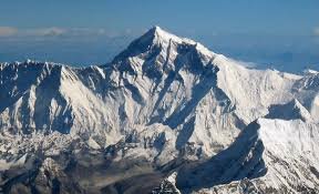
Mount Everest, the highest peak in the world, has long captivated the imagination of explorers, climbers, and scientists alike. Standing at a towering 8,848.86 meters (29,031.7 feet) above sea level, Mount Everest is located in the Himalayas, straddling the border between Nepal and the Tibet Autonomous Region of China. Its immense height and breathtaking beauty make it one of the most famous natural landmarks on Earth.
Geographical Location of Mount Everest
Mount Everest is situated in the Mahalangur mountain range of the Himalayas. The mountain itself is part of the greater Himalayan range, which stretches across several countries in South Asia, including India, Nepal, Bhutan, and Tibet. The summit of Mount Everest lies on the international border between Nepal and China, with its southern entrance located in Nepal and its northern entrance in Tibet.
Climbing Mount Everest
The first successful ascent of Mount Everest was made by Sir Edmund Hillary of New Zealand and Tenzing Norgay of Nepal on May 29, 1953. Since then, thousands of climbers have attempted to summit the peak, although the journey is fraught with challenges due to extreme weather, altitude sickness, and treacherous terrain. Climbing Mount Everest remains a popular but dangerous activity for mountaineers around the world.

Why This News is Important
Significance for Students Preparing for Government Exams
Mount Everest is a crucial part of geographical studies, especially for those preparing for government exams. It is often featured in questions related to physical geography, natural landmarks, and the geography of Nepal and China. Students must understand its location, historical significance, and environmental importance.
Cultural and Economic Impact
Mount Everest holds immense cultural value for the people of Nepal, who revere the mountain as the “Mother Goddess.” Additionally, it contributes significantly to the local economy through tourism, as thousands of trekkers visit the region annually to attempt the base camp trek or summit the peak.
Historical Context
Mount Everest, known as “Sagarmatha” in Nepali and “Chomolungma” in Tibetan, has been a subject of fascination for centuries. The first recorded attempts to locate the peak occurred during British expeditions in the 19th century. The mountain was initially surveyed in 1841 by Andrew Waugh, the British Surveyor General of India, who officially named it after Sir George Everest, a former British surveyor. Over the years, expeditions from around the world have aimed to climb the peak, with various milestones achieved, including the historic first ascent in 1953 by Hillary and Norgay. Today, Mount Everest is an iconic symbol of natural beauty, adventure, and the spirit of human endurance.
Key Takeaways from “Where Is Mount Everest Located?”
| S.No | Key Takeaway |
|---|---|
| 1 | Mount Everest is the highest mountain in the world, standing at 8,848.86 meters above sea level. |
| 2 | It is located on the border between Nepal and Tibet, in the Mahalangur mountain range of the Himalayas. |
| 3 | The mountain was named after Sir George Everest, the British surveyor who first measured it. |
| 4 | The first successful summit of Mount Everest was achieved by Sir Edmund Hillary and Tenzing Norgay in 1953. |
| 5 | Mount Everest is of significant cultural, economic, and geographical importance to Nepal and Tibet. |
Important FAQs for Students from this News
Q1: What is the height of Mount Everest?
A1: Mount Everest stands at a height of 8,848.86 meters (29,031.7 feet) above sea level.
Q2: Where is Mount Everest located?
A2: Mount Everest is located on the border between Nepal and the Tibet Autonomous Region of China, in the Mahalangur mountain range of the Himalayas.
Q3: Who were the first people to successfully climb Mount Everest?
A3: The first successful ascent of Mount Everest was made by Sir Edmund Hillary of New Zealand and Tenzing Norgay of Nepal on May 29, 1953.
Q4: What is the local name of Mount Everest in Nepal and Tibet?
A4: In Nepal, Mount Everest is known as “Sagarmatha,” and in Tibet, it is called “Chomolungma.”
Q5: Why is Mount Everest important in terms of geography?
A5: Mount Everest is significant as the highest point on Earth, making it a critical reference for physical geography, geological studies, and geographical landmarks. Its location is often featured in exams related to global geography.
Some Important Current Affairs Links


